Maintaining Obereisenbach´s natural diversity
Concern for plants and animals
The VAUDE company headquarters in Tettnang-Obereisenbach are located on the southern outskirts of Obereisenbach, a small town near Lake Constance in southern Germany. To the north of the grounds is a residential area while to the east, south and west of the facilities are meadows and wooded areas used for agriculture and forestry.
The product development and management divisions, storage, bag production and maintenance facilities as well as the VAUDE Child Care Center are located on the grounds.
1,500 square meters of parking space unsealed and greenscaped
In 2014 and 2015, VAUDE remodeled a building that had been previously used for storage into office spaces, and completely modernized the remaining office building. The result is an ultra-modern, energy-efficient and environmentally-certified DGNB administration building. The maintenance of biodiversity was incorporated in the building permit process.
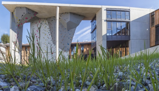
Particularly environmentally friendly: as part of the reconstruction, about 1,500 square meters of parking was completely unsealed and replaced by species-rich, semi-natural grassland and flowering fields! More information on the change here .
The VAUDE property measures a total of 34,696 square meters. 56 percent of this area is paved or cultivated. 2,200 m2 of the paved outer surface consist of a special drain stone pavement for a parking lot which is also used for large events. This does not seal the surface completely, allowing rainwater to seep through, while also preventing the surface from heating up too much and allowing small organisms to live in between the cracks.
The VAUDE factory sales and the certified organic VAUDE café, which also serves employees as a cafeteria, are located on the western edge of Obereisenbach. This area measures 3,290 square meters, of which 94 percent is paved.
Geographically, the company premises belong to the Upper Tannauer Valley. In its geological history, a reservoir was formed here during a prolonged ice withdrawal stage in which the area was cut off from moraines in the east, west and north in addition to a glacier in the south.
Abundant fine clay deposits left behind by the former lake, low slopes of the valley region as well as the hillside springs (especially those emerging at the foot of the moraines) are characteristic to the area. This results in extensive quagmires in the low-lying valley regions and hillside spring marshes, especially at the foot of the northern and eastern moraines. Large ponds expanded throughout the valley in the Middle Ages. This valley is used today almost completely as grassland yet it still features many areas of wetland vegetation.
The highest grades of species and habitat protection are achieved at the foot of forested slopes, where nutrient-poor, calcareous groundwater exits or is near to the surface. Particularly worth mentioning is the Upper Pond area near Obereisenbach (4.1.1, § 24a 8323-435-6566 / forest biotope 8323-0126), in which even Davall's Sedge or Great Fen-Sedge – spread into lime-rich swamps (FFH 7230 II P) and moor grass meadows (§ 24a 8323-435-6567, FFH 6410 II HN). However, here tall forbs and neophytes are spreading out as well.
These grades have not resulted in an increased legal protection status. Although in recent times, (very small sub-areas) have been designated as conservation areas.
However, it must not be forgotten that these areas are only remnants compared to the original numbers. GÖTTLICH (1975) already identified 9 hectares of meadow and 8 hectares of damp grassland, which in the meantime has been reduced to less than 4 hectares. The loss is due to disuse, and near the edge of the Arlen wood, to afforestation as well. Only the continuation of 2 hectares is protected through regular maintenance.
Meadow orchards are typical for and quite widespread in the region and around the ponds. Generally, from the perspective of the habitat network, the conservation, optimization and expansion of these orchards, as well as the maintenance and development of the landscape should be supported.
Excerpt from: Biotope survey 2002, Schmelzer + Friedemann

|
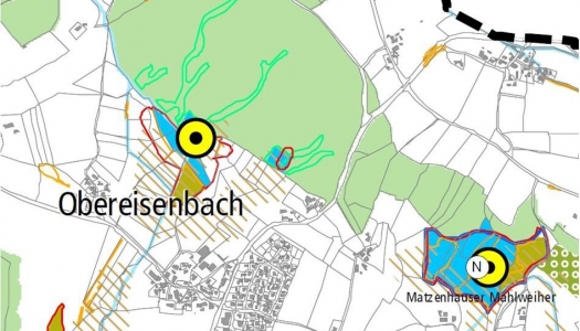
Landscape Plan 2020
The blue and olive surfaces are hay meadows, the yellow dots indicate regional species, the shaded areas are marshes, and the red and green borders are nature conservation areas. |
According to the 2002 biotope mapping of the Tannauer Valley, compensatory measures for construction sites are to be primarily carried out in the biodiversity "hot spots" specified therein. This also includes, in VAUDE’s case, the Obereisenbach pond, where a restoration project for hillside springs and hay meadows is used as a compensatory measure for our building operations.

|
Our Location
In Tettnang-Obereisenbach, how we deal with biodiversity is up to us. In respect to our suppliers, we need to do more to raise awareness for this issue. |
“Our” stream
In one of our projects we are renaturalizing a stream flowing through our premises. You can read more about it at Projects.
Four threatened species
According to the biotope mapping of the Upper Tannauer Valley, in the area in which the VAUDE premises are located, four out of 13 threatened Category A species are found here - species that are threatened with extinction nationwide.
- Marsh Fritillary (Euphydryas aurinia)
- Tufted Marbled Skipper (Carcharodus floccifera)
- Scarce Large Blue (Maculinea teleius)
- Geyer’s Whorl Snail (Vertigo geyeri)
These species require near-natural marshes as their habitat. These small areas can still be found today maintained as wetland meadows in the Tettnang-Obereisenbach region.
Species introduced by sea freight
The introduction of invasive species by ocean freight from our production countries poses a potential risk to biodiversity at the Tettnang-Obereisenbach location. As part of a project "Green Logistics", a campaign to raise awareness on this topic among business partners and logistics service suppliers is planned.
In the supply chain, our business activities also have an impact on biodiversity (also see Pioneer in Biodiversity Checks). For all business activities outside of the Tettnang-Obereisenbach site, there is no data available as yet.
| GRI: | G4-EN11 |
| GRI: | G4-EN12 |
| GRI: | G4-EN14 |
| GRI: | G4-DMA Biodiversity |


